首页 | 本学科首页   官方微博 | 高级检索  
     

联合NDRI特征和空间相关性的机载MS-LiDAR数据分类
引用本文:王丽英,有泽,吴际,CAMARA Mahamadou.联合NDRI特征和空间相关性的机载MS-LiDAR数据分类[J].红外与激光工程,2023,52(2):20220376-1-20220376-11.
作者姓名:王丽英  有泽  吴际  CAMARA Mahamadou
作者单位:1.辽宁工程技术大学 测绘与地理科学学院,辽宁 阜新 123000
基金项目:国家自然科学基金(42201482; 62105240)
摘    要:
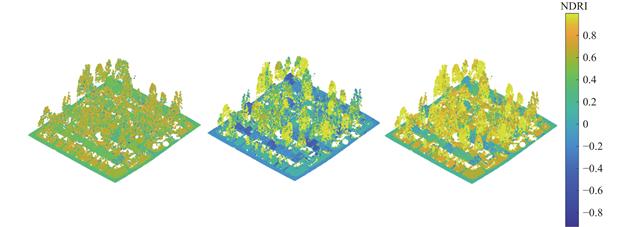
对比仅包含多光谱信息、仅可实现二维土地覆盖分类的传统光学遥感数据,机载多光谱激光雷达(multispectral light detection and ranging,MS-LiDAR)的优势在于同时包含多光谱和空间信息、可实现三维土地覆盖分类,但现有的机载MS-LiDAR数据的土地覆盖分类研究所需特征维度过高、算法复杂度高。因此,提出了一种整合空间相关性和归一化差分比率指数(Normalized Difference Ratio Index,NDRI)特征的逐步分类算法。该算法首先融合机载MS-LiDAR数据的多波段独立点云,获取兼具空间位置及其多光谱信息的单一点云数据;然后利用空间邻域增长下的地面滤波算法分离地面和非地面点;接着基于不同目标的激光反射特性差异设计将草地(树木)自地面(非地面)中分离的NDRI指数,并利用类间方差最大原则下的自适应最优NDRI指数实现地面和非地面点的精细分类;最后利用3D多数投票法优化分类结果。采用加拿大Optech Titan实测MS-LiDAR数据测试提出算法的有效性及可行性,实验结果表明:算法的平均总体精度和Kappa系数分别可达90.17%和...

关 键 词:机载多光谱激光雷达  点云分类  三维土地覆盖分类  归一化差分比率指数  滤波
收稿时间:2022-05-31

Airborne MS-LiDAR data classification by combining NDRI features and spatial correlation
Affiliation:1.School of Geomatics, Liaoning Technical University, Fuxin 123000, China2.Heilongjiang Institute of Geomatics Engineering, Harbin 150081, China
Abstract:Compared with conventional optical remote sensing data, which contain only multispectral information and can only realize two-dimensional land cover classification, the advantage of airborne multispectral light detection and ranging (MS-LiDAR) is that it contains both multispectral and spatial information and can realize three-dimensional land cover classification. However, the existing land cover classification methods for airborne MS-LIDAR data require too high feature dimension to distinguish all kinds of objects simultaneously and have high algorithm complexity. So, a stepwise classification algorithm combining spatial and normalized difference ratio index (NDRI) features is proposed. Firstly, the multi-band independent point clouds of airborne multispectral LiDAR are merged to obtain the merged point cloud data with spatial location and their multispectral information. Secondly, based on the elevation consistency of urban ground spatial adjacent points, a ground filtering algorithm under spatial neighborhood growth is used to separate ground and non-ground points. Thirdly, based on the difference of laser reflectance characteristics of different objects, the NDRI index is designed to separate the grass (tree) from the ground (non-ground), and the adaptive optimal NDRI index under the principle of maximum inter-class variance is used to achieve the fine classification of ground and non-ground points. Finally, 3D majority voting is used to alleviate the noise in the previous classification result in order to further optimize classification result. The proposed algorithm makes comprehensive use of the spatial and multispectral features contained in multispectral LiDAR data, and the step-by-step processing method is more convenient to design simple and effective rules according to the characteristics of specific separation objects. The effectiveness and feasibility of the proposed algorithm are tested by using Optech Titan airborne multi-spectral LiDAR data of different scenes. The experimental results show that: (1) The average overall accuracy and Kappa coefficient of the proposed algorithm can reach 90.17% and 0.861, this demonstrates that the proposed algorithm can realize the accurate three-dimensional land cover classification of the multi-spectral LiDAR data in urban areas. (2) The step-by-step processing method adopted by the proposed algorithm is more convenient for designing simple and effective rules according to the characteristics of specific separation objects. The algorithm design is simple and the complexity is low. (3) The availability of NDRI features designed to distinguish between grass (trees) and road (buildings) can provide theoretical support for the design and selection of salient features of other machine learning algorithms.
Keywords:
点击此处可从《红外与激光工程》浏览原始摘要信息
点击此处可从《红外与激光工程》下载全文
设为首页 | 免责声明 | 关于勤云 | 加入收藏

Copyright©北京勤云科技发展有限公司  京ICP备09084417号